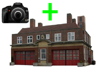
| Name: | Maesteg old fire station 3 site |
| Address: | r/o Town Hall, Church Street |
| Town: | Maesteg |
| Brigade: | South Wales |
| Postcode: | |
| | |
| Year Range: |
1938-? (demolished) |
| | |
Confirmed
Latitude/Longitude: | 51.608443 North
03.658034 West |
| | |
| Further Information/ Provenance: | |
Shown on 1939 1:2500 OS map, still on 1951 1:1250 OS map (possibly slightly different location?), still on 1960/1970 1:1250 OS map, still on 1962 1:2500 OS map
Maesteg Memories FB group
- post 12/02/2014 has photo in 1977 and states opened 1938
|
| |
| |
| If any of this information is incorrect, or you can supply further details (confirmed address, location, years of use etc), please click here to send details |
Return to previous page |

 Upload an image of this Fire Station

