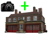
| Name: | Rochdale old fire station 3 |
| Address: | School Lane |
| Town: | Rochdale |
| Brigade: | Greater Manchester |
| Postcode: | |
| | |
| Year Range: |
?-? |
| | |
Very Rough Plot:
Latitude/Longitude: | 53.614689 North
02.156367 West |
| | |
| Further Information/ Provenance: | |
http://www.link4life.org/index.cfm?fuseaction=c.showPage&pageID=969
very rough plot - no obvious building on streetview 2010
Not marked on available OS maps July 2011
|
| |
| |
| If any of this information is incorrect, or you can supply further details (confirmed address, location, years of use etc), please click here to send details |
Return to previous page |

 Upload an image of this Fire Station

