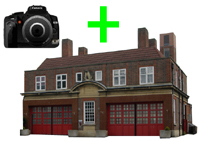
| Name: | Innerleithen old fire station site |
| Address: | Coll Road, off Traquair Road |
| Town: | Innerleithen |
| Brigade: | Lothian & Borders |
| Postcode: | |
| | |
| Year Range: |
?-1977 (demolished) |
| | |
Confirmed
Latitude/Longitude: | 55.616699 North
03.066409 West |
| | |
| Further Information/ Provenance: | |
http://www.graemekirkwood.co.uk/LB/40.htm
Shown on 1966 1:2500 OS map
Google Earth shown building December 2011, but streetview shown new houses built on site
|
| |
| |
| If any of this information is incorrect, or you can supply further details (confirmed address, location, years of use etc), please click here to send details |
Return to previous page |

 Upload an image of this Fire Station

